Vail Mountain 3D Maps

Vail Mountain 3D Maps

We Build Custom 3D Vail Mountain Maps

Did you know we make

large 3D Maps?

Monterey 3D-printed topography map model with custom pedestal base

Secrets of Vail Mountain 3D Maps

Nestled amidst the rugged beauty of the Colorado Rockies, Vail Mountain Ski Resort stands as an iconic winter playground, beckoning snow enthusiasts from around the world.  With its vast network of meticulously groomed slopes, pristine powder bowls, and enchanting alpine scenery, Vail Mountain has earned its reputation as a premier destination for skiers and snowboarders seeking the ultimate winter adventure.  Now, introducing our cutting-edge 3D maps for Vail Mountain, we invite you to embark on a journey that will revolutionize the way you experience this alpine paradise.

Our 3D maps are your gateway to an unparalleled skiing and snowboarding experience.  As you step into the world of Vail Mountain, these maps will serve as your trusted companions, providing you with an unprecedented level of detail and insight into the terrain, trails, and facilities that make this resort a true winter wonderland.  Join us as we unveil the extraordinary features and capabilities of these maps, designed to elevate your Vail Mountain adventure to new heights, ensuring every moment on the slopes is an unforgettable one.  Welcome to a new era of exploration in the realm of winter sports.

Exploring Vail Mountain with 3D Maps

Tailored Adventures:  Vail Mountain offers an array of terrain options, from gentle groomers to challenging chutes.  3D maps allow you to plan your day meticulously, ensuring you explore terrains that align with your skill level and interests.

Backcountry Exploration:  Beyond the groomed runs, Vail Mountain offers remarkable backcountry opportunities.  With 3D maps, adventurous skiers and snowboarders can navigate safely in this untamed wilderness.

Discover Hidden Treasures:  3D maps reveal hidden gems on the mountain that may not be immediately obvious on traditional trail maps.  From secret powder stashes to thrilling tree runs, these maps help you uncover the mountain’s best-kept secrets.

Community Insights:  Many 3D map applications encourage users to contribute their experiences through trail reviews, photos, and comments.  This communal aspect enriches your understanding of the mountain and helps you uncover valuable insider tips.

Park City Topographic Map 1 Park City 3D Raised Relief Map    

Features of 3D Maps for the Vail Mountain Ski Resort

3D raised relief maps prove to be indispensable tools when it comes to comprehending and navigating the captivating alpine landscapes of  Vail Mountain Ski Resort in three dimensions.  These innovative maps offer a tactile and lifelike representation of the resort’s terrain, enhancing the way visitors interact with and appreciate the mountainous surroundings.  Let’s explore the unique features of 3D maps tailored to the Vail Mountain experience:

Physical Representation

Crafted from materials such as plastic, resin, or foam, 3D raised relief maps physically manifest Snowbasin’s geographical features, including its majestic peaks, thrilling slopes, and pristine valleys.  These models faithfully mirror the shape and elevation of the resort’s terrain, providing a hands-on experience of the mountain.

Comprehensive Terrain Representation

Our 3D Maps for Vail Mountain provide a complete, three-dimensional representation of the entire resort and its surroundings.  Every peak, valley, and trail is meticulously rendered, allowing you to explore the mountain as if you were there in person.  Whether you’re a skier, snowboarder, hiker, or mountain biker, this comprehensive terrain representation is an invaluable tool for planning your adventures.

Interactive Elevation Profiles

Gain a deeper understanding of Vail Mountain’s topography with interactive elevation profiles.  These profiles allow you to visualize the steepness of slopes, the elevation gain and loss along your chosen routes, and the overall difficulty of trails.  Whether you’re searching for challenging descents or gentle slopes, our elevation profiles help you make informed decisions to match your skill level and preferences.

Topographic Detail

Vail Mountain’s 3D maps meticulously capture the intricate topographic details of the resort, showcasing elevation changes, slope gradients, and contour lines.  Skiers and snowboarders can visually assess the steepness of the runs, the depth of valleys, and the flow of trails, gaining a profound understanding of the resort’s topography.

Scale and Size

Available in various scales and sizes, Vail Mountain’s 3D maps cater to diverse preferences and needs.  From compact tabletop models ideal for educational purposes to grand wall-mounted displays suitable for decorative or planning purposes, visitors can choose the scale that best suits their intended use.

Color and Texture

Color-coded representations on these maps distinguish different types of terrain and land cover, such as vibrant green for forests, serene blue for water bodies, and earthy brown for rugged mountains.  Some maps also incorporate texturing to emulate the unique surface characteristics of Vail Mountain’s landscape.

Customization

Vail Mountain’s 3D maps can be customized to include specific geographic features unique to the resort.  This allows for a personalized representation that includes details such as ski lifts, ski runs, lodges, and other iconic landmarks, making it a valuable tool for both orientation and planning.

Educational Value

Beyond their navigational utility, Vail Mountains’s 3D maps serve as invaluable educational aids, enhancing the understanding of geographical concepts and the resort’s dynamic landscape.  These educational tools find applications in schools, museums, and geographical research, fostering a deeper appreciation for the natural world.

Orientation and Elevation Information

To assist visitors in navigating the resort effectively, Vail Mountain’s 3D maps often incorporate orientation markers like compass roses and north arrows.  They also provide quantitative elevation information through contour lines and numerical values, aiding in height assessment throughout the mountainous terrain.

Interactive Features

Modern 3D relief maps at Vail Mountain Ski Resort may feature interactive elements, including LED lighting to highlight specific areas, touch-sensitive surfaces for accessing additional information, and augmented reality (AR) capabilities for an immersive exploration of the resort’s terrain.

Decorative Purposes

In addition to their educational and functional roles, Vail Mountains’s 3D maps serve as stunning decorative pieces, enhancing the ambiance of homes, offices, and public spaces. Their intricate designs and lifelike representations celebrate the aesthetic beauty of Vail Mountain, making them visually appealing additions to any environment.

3D Maps for Vail Mountain is your gateway to unlocking the full potential of this incredible natural playground. With these robust features at your fingertips, you can confidently plan, navigate, and immerse yourself in the awe-inspiring beauty and excitement that Vail Mountain has to offer.  Whether you’re a seasoned local or a first-time visitor, our 3D Maps are your essential companion for exploring this mountain paradise.

How 3D Maps Are Made: Unveiling the Magic Behind the Scenes

3D maps have revolutionized the way we navigate and explore the world around us, offering immersive and detailed representations of landscapes, cities, and natural wonders. But have you ever wondered how these intricate 3D maps are created?  Let’s take a peek behind the curtain to uncover the magic of 3D map-making.

Data Acquisition: The Foundation of 3D Maps

At the core of any 3D map creation process is the acquisition of spatial data.  This data forms the foundation upon which the 3D map is built.  Several methods are commonly employed to gather this crucial information:

  • Aerial Imagery:  Aerial photography and remote sensing techniques, including LiDAR (Light Detection and Ranging), capture high-resolution images and elevation data from airplanes or drones.  LiDAR, in particular, provides detailed 3D point cloud data by measuring the distance between the sensor and the Earth’s surface.

  • Satellite Imagery:  Satellite-based remote sensing technologies collect vast amounts of data covering large areas.  This data includes color imagery, infrared imagery, and elevation data, allowing for a comprehensive view of the terrain.

  • Ground-Based Surveys:  Surveyors use terrestrial LiDAR scanners, GPS technology, and other instruments to collect precise data from the ground. This data is often used to complement and refine aerial or satellite data.

Data Processing: Transforming Raw Data into 3D Models

Once the raw data is collected, it undergoes extensive processing to convert it into usable 3D models.  This processing includes:

  • Data Alignment:  Merging data from various sources and ensuring that it is accurately aligned in a common coordinate system is a crucial step.  This alignment ensures that the 3D map accurately represents the real-world terrain.

  • Point Cloud Processing:  For LiDAR data, point clouds are generated, where each point represents a specific location in 3D space.  Filtering and classification algorithms are used to separate ground points from non-ground points (such as vegetation or buildings).

  • Mesh Generation:  To create a more detailed 3D representation, the point cloud is converted into a mesh.  This mesh consists of interconnected triangles that form the surface of the terrain.

  • Texture Mapping:  Aerial and satellite images are draped onto the 3D mesh to provide color and texture, making the map visually appealing and realistic.

Visualization and Interaction: Making 3D Maps User-Friendly

Creating a 3D map is not just about data; it’s about making it accessible and user-friendly. Here’s how:

  • User Interface Design:  Designing an intuitive user interface is crucial to allow users to interact with the 3D map effectively.  This includes navigation controls, search functions, and overlay options.

  • Web-Based Platforms:  Many 3D maps are accessible through web-based platforms or dedicated apps, making them available to a wide audience via computers, smartphones, and tablets.

  • Customization:  Users often have the ability to customize their 3D map experience by choosing different layers, map styles, and viewing options to suit their needs and preferences.

3D maps are a fascinating blend of data collection, processing, visualization, and technology integration.  They provide us with powerful tools for navigation, exploration, and understanding of our world, and they continue to evolve, offering new possibilities for both practical and recreational applications. 

Top 10 Lifts at Vail Mountain

Navigating the expansive terrain of Vail Mountain Ski Resort can be an exhilarating experience, and our 3D maps are your ultimate companion for exploring the top 10 lifts that make this destination a winter paradise.  Whether you’re a seasoned skier or a first-time visitor, these maps will ensure you make the most of your time on the slopes.

  • Gondola One (Lift 1):  Located in Vail Village, Gondola One provides access to mid-Vail and serves as a gateway to various trails on the mountain.
  • Eagle Bahn Gondola (Lift 19):  This gondola, located in Lionshead Village, offers access to a variety of terrain, including Blue Sky Basin and Game Creek Bowl.
  • Avanti Express (Lift 2):  Avanti Express provides quick access to intermediate and advanced terrain on the front side of the mountain, including popular runs like Avanti and Northwoods.
  • Wildwood Express (Lift 3):  Wildwood Express is another key lift for accessing intermediate and advanced terrain, serving runs like Riva Ridge and Game Creek Bowl.
  • Mountaintop Express (Lift 4):  Located at the top of the mountain, this lift provides access to the China Bowl and Blue Sky Basin, known for its powder-filled bowls and gladed terrain.
  • High Noon Express (Lift 5):  High Noon Express is a popular choice for intermediate skiers and snowboarders, offering access to numerous blue and black runs on the front side.
  • Game Creek Express (Lift 7):  This lift provides access to Game Creek Bowl, known for its challenging terrain and stunning alpine views.
  • Northwoods Express (Lift 11):  Northwoods Express serves as a gateway to some of Vail’s iconic advanced and expert runs, including Northwoods and Siberia Bowl.
  • Sourdough Express (Lift 14):  Located in the Blue Sky Basin area, Sourdough Express provides access to a wide range of tree skiing and powder runs.
  • Sun Up Express (Lift 9) and Sun Down Express (Lift 5):  These lifts are part of the Sun Up and Sun Down Bowl areas, offering access to an array of challenging terrain and beautiful backcountry experiences.

By utilizing our 3D Maps and exploring these top lifts, you’ll be well on your way to making the most of your visit to Vail Mountain, experiencing the thrill of the slopes, the serenity of the backcountry, and the beauty of this remarkable mountain destination.

Top 10 Runs at Vail Mountain

Vail Mountain is renowned for its diverse and thrilling ski and snowboard runs, offering something for everyone, from beginners to experts.  To make the most of your adventure on the mountain’s top 10 runs, our innovative 3D maps are the ultimate tools for guidance and exploration

  • Riva Ridge:  Known for its steep and challenging terrain, Riva Ridge is a favorite among expert skiers.  It offers a thrilling descent and stunning views. 
  • Highline:  This double black diamond run provides a challenging and exhilarating experience with its steep pitch and moguls. 
  • Blue Ox:  A well-groomed intermediate run, Blue Ox is perfect for those looking for a scenic and enjoyable descent through the trees.
  • Forever:  This long and winding blue run takes you from the summit to the base of the mountain, offering breathtaking views and varied terrain.
  • Genghis Khan:  Part of the famous Back Bowls, Genghis Khan is an intermediate run offering deep powder and open bowl skiing.
  • Prima:  Prima is a wide-open, groomed blue run located on the front side of the mountain, providing a fun and scenic descent.
  • Ouzo:  For advanced skiers, Ouzo offers a steep and challenging tree run with powder-filled glades.
  • Ricky’s Ridge:  This is another fantastic option for advanced skiers, featuring steep pitches and moguls for an adrenaline-pumping descent.
  • Champagne Glade:  Located in Blue Sky Basin, this gladed area provides a serene experience through the trees, perfect for those seeking a peaceful adventure.
  • Bwana:  Bwana is a scenic intermediate run located in the Sun Down Bowl area, offering varied terrain and beautiful alpine scenery.

With our 3D Maps and this list of top runs, you’re well-equipped to embark on an unforgettable adventure at Vail Mountain.  Whether you’re chasing steep chutes, pristine powder, or leisurely groomers, these resources will help you make the most of your time on the mountain, ensuring an incredible experience every step of the way.

3D Map Styles for Vail Mountain

When it comes to experiencing the stunning beauty and diverse terrain of Vail Mountain, different 3D map styles can provide unique perspectives and aid in your navigation.  Exploring Vail Mountain is a dynamic and personalized experience, and our 3D Maps offer a variety of styles to cater to different preferences and needs. These map styles not only provide visual appeal but also serve as essential tools for navigating the diverse terrain.  Let’s dive into the four primary 3D map styles available for Vail Mountain:

Google Maps Satellite Style

Overview:  Google Maps Satellite Style provides a high-resolution satellite view of Vail Mountain, offering a bird’s-eye perspective of the terrain, slopes, and surrounding landscape.

Advantages:

Terrain Clarity – This style offers excellent clarity for identifying ski runs, lifts, and trails, making it easier to plan your routes.

Visual Realism – The satellite imagery provides a realistic representation of the mountain’s topography, enhancing your understanding of the terrain.

Snow Conditions – You can often gauge real-time snow coverage and conditions by observing the mountain’s appearance in satellite imagery.

Vail Mountain - Google Maps Satellite Style 
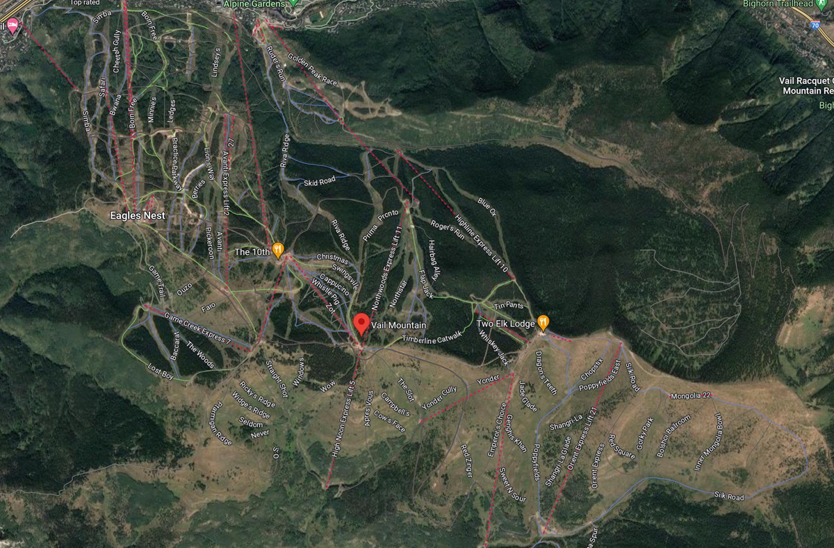
Vail Mountain Map – Google Maps Satellite Style


Google Maps Terrain Style

Overview:  Google Maps Terrain Style combines topographic data with 3D rendering, providing a clear view of elevation changes and natural features on Vail Mountain.

Advantages:

Elevation Awareness – This style helps you visualize elevation differences, which can be crucial for understanding the steepness and layout of ski runs.

Trail Identification – The combination of terrain features and labeled trails assists in route planning and navigation.

Terrain Context – You can gain a better sense of how Vail Mountain fits into the broader landscape of the Rocky Mountains.

Vail Mountain - Google Maps Terrain Style 
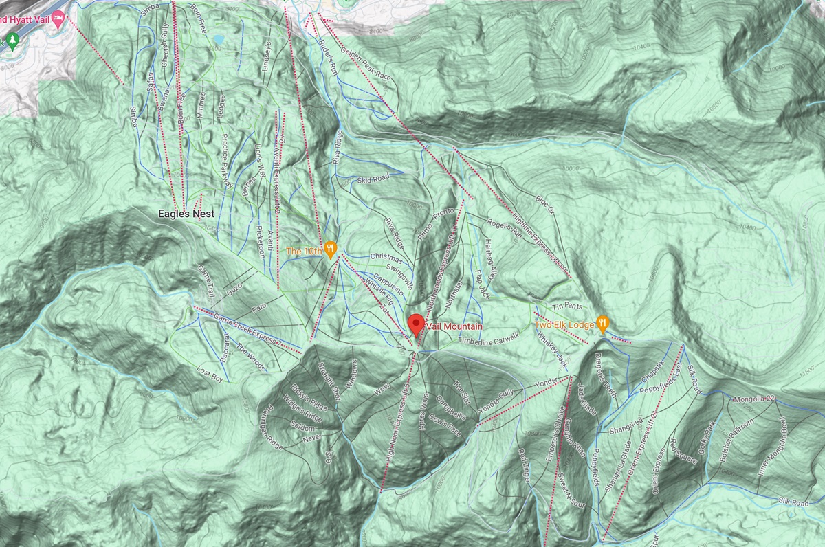
Vail Mountain Map – Google Maps Terrain Style


Google Earth Style

Overview:  Google Earth Style takes the 3D mapping experience to the next level by offering an interactive globe with 3D-rendered mountains, valleys, and landmarks.

Advantages:

Immersive Exploration – Google Earth Style provides a highly immersive and interactive way to explore Vail Mountain in 3D.

Detailed Aerial Views – You can zoom in on specific areas, getting close-up views of slopes, lifts, and surrounding features.

Historical Imagery – In some cases, Google Earth may offer historical imagery, allowing you to compare past and present conditions on the mountain.

Vail Mountain - Google Earth Style 
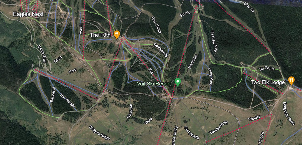
Vail Mountain Map – Google Earth Style


Customized Map Styles

Overview:  Customized map styles allow you to tailor the map to your specific preferences, highlighting the information that matters most to you.

Advantages:

Personalization – You can customize the map’s appearance by adjusting elements like trail colors, labeling, and markers.

Focus on Key Features – Create styles that emphasize top 10 runs, lifts, or points of interest, making it easier to plan your day on the mountain.

Enhanced Readability – Customize the map to ensure that it aligns with your personal preferences for readability and clarity.

Each of these 3D map styles offers a distinct perspective on Vail Mountain, allowing you to choose the one that best suits your needs and preferences.  Whether you’re seeking a realistic view, elevation insights, an immersive experience, or a customized approach, these map styles enhance your exploration of one of the premier ski destinations in the world.

Elevate Your Vail Mountain Adventure with 3D Maps

In the world of winter sports, Vail Mountain stands as an icon of natural beauty, adventure, and excitement.  Whether you’re a seasoned pro or a first-time visitor, the mountain’s sprawling terrain, diverse runs, and breathtaking vistas offer an endless playground for skiers and snowboarders of all levels.  To help you navigate this alpine paradise and make the most of your experience, our 3D maps for Vail Mountain have been designed to be your trusted companions.

As you explore Vail Mountain with these innovative maps, you gain more than just a wayfinding tool; you gain a deeper connection to the mountain itself.  You’ll discover new trails, uncover hidden gems, and experience the thrill of skiing and snowboarding with newfound confidence.

Our 3D maps are more than maps; they’re your gateway to memorable moments, to the serenity of untouched powder, to the exhilaration of conquering challenging slopes, and to the camaraderie of sharing your adventures with fellow mountain enthusiasts.

So, whether you’re planning your first visit to Vail Mountain or you’re a seasoned regular, embrace the opportunity to enhance your alpine experience with 3D maps that not only guide you but also help you create lasting memories on one of the most spectacular mountains on the planet.  With these maps in hand, your Vail Mountain adventure reaches new heights, and your journey becomes a story to be cherished and shared for years to come.

Check out WhiteClouds’ 3D Maps for more information on 3D maps of Vail Mountain Ski Resort.   2D Large Canvas Print Vail Mountain Maps are also available. 

Contact us today to learn more about our 3D services and how we can help you achieve your goals. Maps      

Get a free quote

Get a Free Quote