
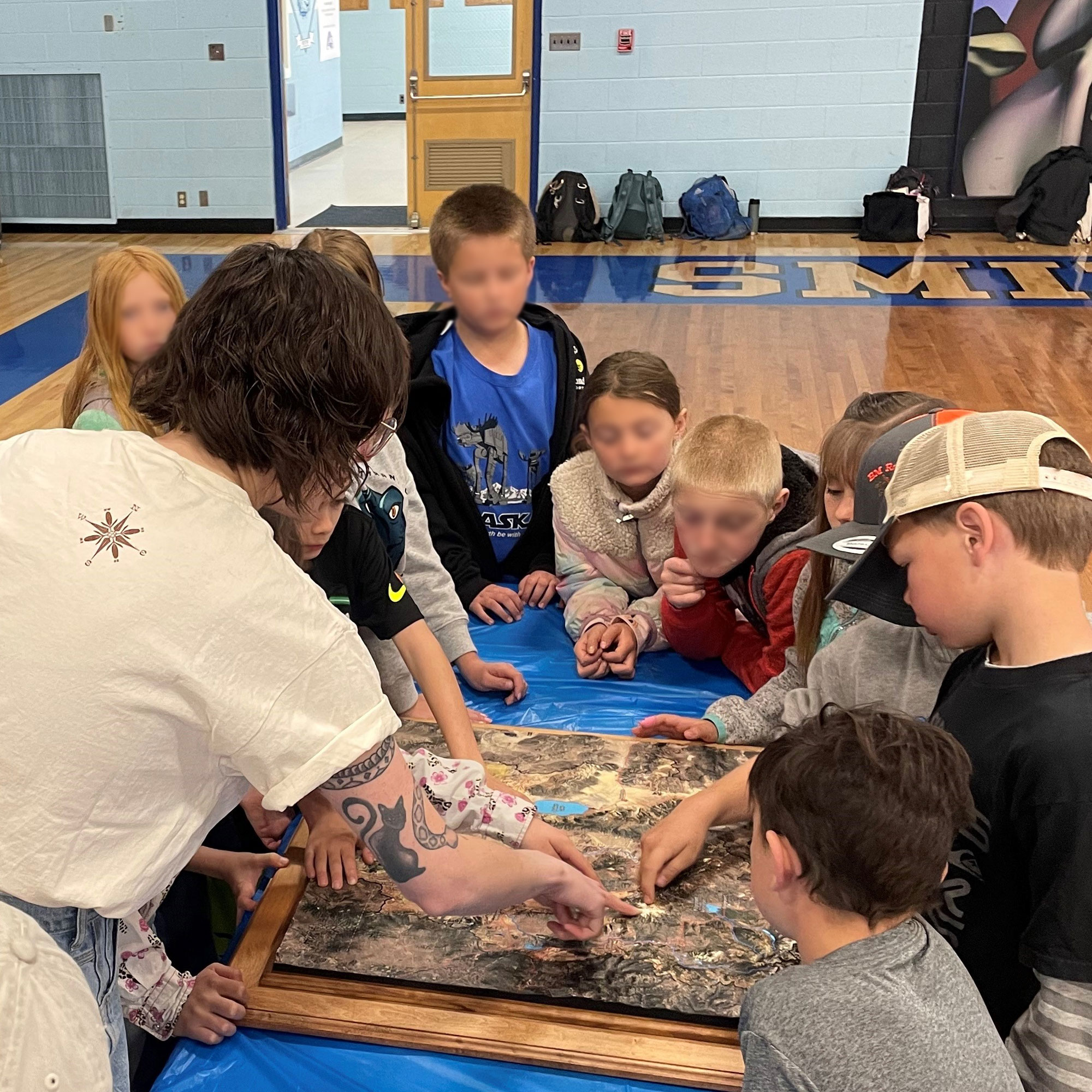
Unveiling Walker Basin: A 3D Journey through Watersheds
Welcome to Walker Basin, where the convergence of land and water creates a mesmerizing tapestry of natural wonders. In this blog, we dive into the depths of Walker Basin’s watershed with a 3D map that brings its intricate ecosystem to life. Join us as we explore the fabrication process of 3D watershed maps and unlock the secrets hidden within Walker Basin’s aquatic realm.
Discovering Walker Basin: Nature’s Aquatic Haven
Nestled amidst the rolling hills and rugged landscapes of California, Walker Basin is a sanctuary for biodiversity and natural beauty. Its network of rivers, streams, and wetlands sustains a rich ecosystem teeming with life. From the snow-capped peaks of the Sierra Nevada to the lush valleys below, Walker Basin’s watershed is a vital lifeline for both humans and wildlife alike.
The Power of 3D Mapping: A New Perspective on Watersheds
Traditional maps offer a glimpse into the layout of the land, but they often fail to capture the dynamic nature of watersheds. This is where 3D mapping technology comes into play, revolutionizing how we perceive and understand the intricate interplay between land and water. By bringing the landscape to life in three dimensions, 3D watershed maps provide a deeper insight into the flow of water and the health of ecosystems like Walker Basin.
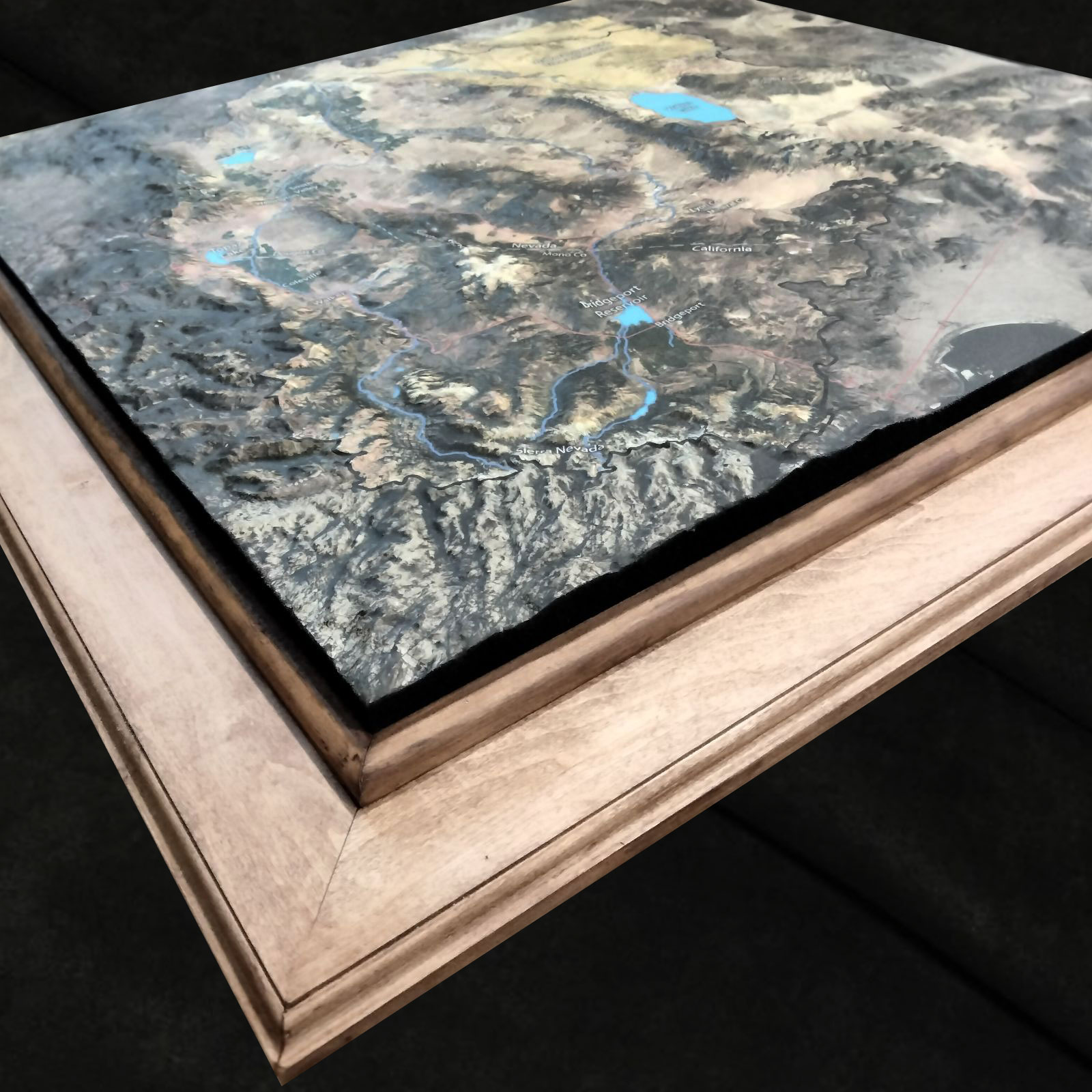
Crafting the Walker Basin 3D Watershed Map: A Meticulous Process
Creating a 3D watershed map is no simple task – it requires precision, expertise, and a deep understanding of hydrology. Here’s a glimpse into how the Walker Basin 3D Watershed Map comes to life:
Data Collection: The journey begins with gathering extensive data about Walker Basin’s topography, hydrology, and land use. This includes aerial surveys, satellite imagery, and ground-based measurements, all of which provide crucial insights into the flow of water and the distribution of resources within the watershed.
Digital Modeling: Skilled technicians use specialized software to create a digital model of Walker Basin’s watershed based on the collected data. This digital model serves as the foundation for the 3D map, capturing the intricate network of rivers, streams, and tributaries with unparalleled accuracy.
Hydrological Simulation: To simulate the flow of water within the watershed, advanced hydrological models are employed. These models take into account factors such as precipitation, evaporation, soil permeability, and land cover, allowing researchers to predict how water moves through the landscape under different conditions.
Texture Mapping: High-resolution imagery is overlaid onto the digital model to add realism and detail to the 3D map. From the lush forests that line the banks of rivers to the rocky outcrops that dot the landscape, every feature is meticulously rendered to create a lifelike representation of Walker Basin’s watershed.
Printing and Assembly: Once the digital model is finalized, it’s time to bring it into the physical realm. State-of-the-art 3D printers work tirelessly to transform the digital design into a tangible masterpiece. Layer by layer, the map takes shape, capturing the complexity and beauty of Walker Basin’s aquatic ecosystem.
Unlocking the Secrets of Walker Basin: Exploring the Watershed
Armed with the Walker Basin 3D Watershed Map, researchers, conservationists, and outdoor enthusiasts alike can unlock the secrets hidden within this unique ecosystem. Whether you’re studying the impact of human activities on water quality, planning conservation efforts to protect critical habitats, or simply exploring the beauty of Walker Basin’s rivers and streams, this immersive map offers unparalleled insight into the delicate balance between land and water.
Preserving the Watershed: A Call to Action
In an era of increasing environmental challenges, understanding and preserving watersheds like Walker Basin is more important than ever. By raising awareness of the importance of healthy watersheds and promoting sustainable management practices, we can ensure that future generations continue to benefit from the invaluable resources provided by these vital ecosystems.
Conclusion: A Journey of Discovery
The Walker Basin 3D Watershed Map is more than just a tool – it’s a gateway to understanding and appreciating the intricate web of life that sustains our planet. With its immersive detail and unparalleled accuracy, this innovative map invites us to explore, learn, and ultimately, to cherish the natural wonders of Walker Basin’s aquatic realm. So let us embark on this journey of discovery together, as we uncover the beauty and complexity of one of California’s most precious landscapes.